Collision with wires
Mosquito XE, C-FHEZ
Okotoks, Alberta, 5.5 nm NE
The Transportation Safety Board of Canada (TSB) investigated this occurrence for the purpose of advancing transportation safety. It is not the function of the Board to assign fault or determine civil or criminal liability. This report is not created for use in the context of legal, disciplinary or other proceedings. See Ownership and use of content.
History of the flight
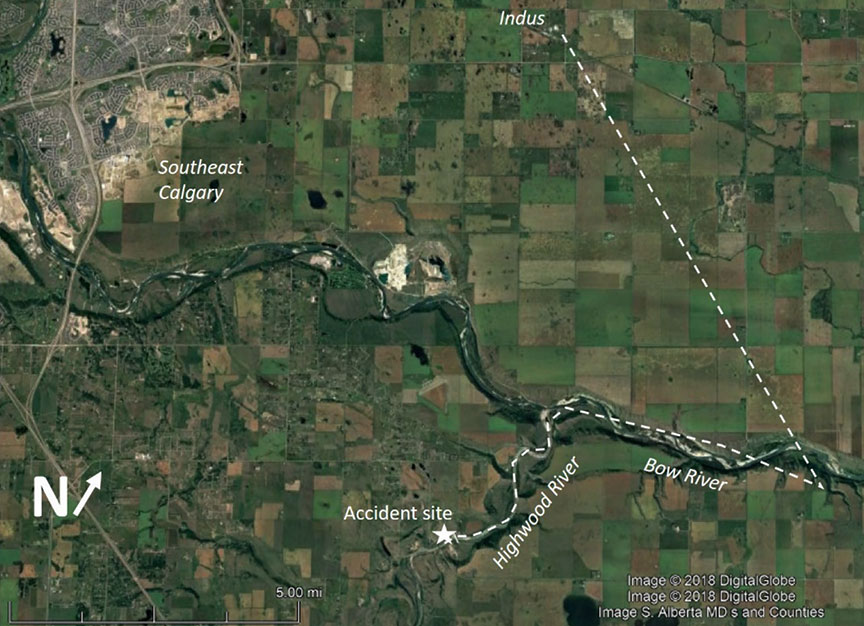
At about 1700Footnote 1 on 15 July 2018, the pilot departed from his residence north of Indus, Alberta, for a local flight in his amateur-built Mosquito XE helicopter (registration C-FHEZ, serial number 1004). The purpose of the flight was to visit a friend who lived south of the Bow River, Alberta, and east of the Highwood River, Alberta (Figure 1).
The pilot was following the Highwood River southwest from the Bow River when the helicopter struck an unmarked power transmission line that was strung across the river at approximately 80 feet above the river. The helicopter departed controlled flight and struck the river bank at about 1740. The aircraft was destroyed and the pilot was fatally injured. There was no post-impact fire, and no emergency locator transmitter (ELT) signal, as no ELT was installed.
Weather information
At the time of the occurrence, southern Alberta was under the influence of a ridge of high pressure, which was centred over the southern Rocky Mountains and extended southeast into the United States. The weather forecast for southern Alberta indicated mainly clear skies with no significant weather, winds, or turbulence.
The 1700 hourly weather observation at Calgary International Airport (CYYC), Alberta, located 22 nautical miles north of the accident site, reported the following:
- winds out of the east at 4 knots
- visibility: greater than 40 statute miles
- few clouds at 15 000 feet and 22 000 feet above ground level
- temperature: 25 °C, dew point 0 °C
- altimeter setting: 30.09 inHg
Pilot information
The pilot was one of the designers of the Mosquito series of amateur-built helicopters. He held both a private pilot – aeroplane licence and a private pilot – helicopter licence, as well as a valid Category 3 medical certificate. He had obtained his private pilot – aeroplane licence in August 1991 and had acquired about 85 total aeroplane flight hours. He had obtained his private pilot – helicopter licence in March 2006 and had acquired approximately 250 total helicopter flight hours. The majority of that time was obtained in the Mosquito series of helicopters. The pilot also had some experience in Robinson R22 helicopters.
Helicopter information
The Mosquito XE is an amateur-built, single-seat helicopter. Construction on the occurrence helicopter was completed in October 2005, and it was registered with Transport Canada in January 2006. Transport Canada issued a special certificate of airworthinessFootnote 2 on 19 March 2006. In the application for the special certificate of airworthiness, the aircraft was described as being equipped with an engine manufactured by Compact Radial Engines (model MZ202), producing 55 hp. However, at the time of the accident, the helicopter was equipped with an Inntec 800 engine, which produces 85 hp. The Inntec 800 is the engine advertised for the Mosquito XE285 model.
Wreckage analysis
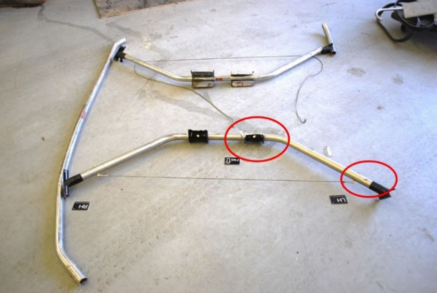
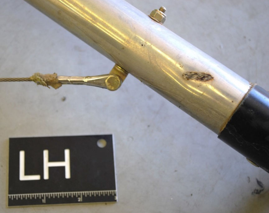
The flight control system was examined and no pre-impact failures were found. Damage to the main rotor and tail rotor systems were consistent with power being developed at the time of the accident. Examination of the helicopter's landing gear revealed that the left side of the forward cross tube struck a wire. Wire strike marks were observed across the forward cross tube (Figure 2 and Figure 3).
Power transmission lines and markings
The power transmission line that was struck included 2 wiresFootnote 3 that were about 8 feet apart. Neither wire was fractured during the collision with the helicopter.
The span across the Highwood River is 1110 feet from the power pole on the north side to the power pole on the south side, which was located next to a residence. The power poles are approximately 35 feet tall. The height of the wires above the surface varied due to changes in terrain along the span. The height of the wire at the point where the helicopter struck it was approximately 80 feet (Figure 4). There were no markers on the wires and none were required by regulation.
Canadian Aviation Regulations (CARs) section 601.23 states that
any building, structure or object, including any addition to it, constitutes an obstacle to air navigation if [...] in the case of any catenary wires crossing over a river, any portion of the wires or supporting structures is higher than 90 m [about 300 feet] AGL [above ground level].Footnote 4Footnote 5
In addition, subsection 601.25(1) of the CARs states,
If the Minister determines that a building, structure or object, other than a building, structure or object described in section 601.23, is hazardous to air navigation because of its height or location, the Minister shall require the person who has responsibility for or control over the building, structure or object to mark and light it in accordance with the requirements of Standard 621.Footnote 6Footnote 7
Before conducting low‑level navigation, a pilot should consult a current Visual Flight Rules (VFR) Navigational Chart (VNC) and VFR Terminal Area Chart (VTA) to identify the location of obstacles along the planned route of flight. If operations near obstacles such as power transmission lines are required, a reconnaissance flight conducted at a higher altitude is the first step in positively identifying their location.Footnote 8
The power transmission line was not marked on the Calgary VNC or the Calgary VTA. Only prominent power transmission lines and cable spans are depicted on these charts.
Low-height wire crossings are very common in Canada, and Transport Canada has stated that it would not be reasonable to require lighting or marking for all of them.
Low flying
The CARs state that “No person shall operate an aircraft in such a reckless or negligent manner as to endanger or be likely to endanger the life or property of any person.”Footnote 9
Regarding minimum altitudes and distances to be flown over non‑built‑up area, the CARs state,
Except where conducting a take-off, approach or landing or where permitted under section 602.15, no person shall operate an aircraft [...] at a distance [vertical or lateral] less than 500 feet from any person, vessel, vehicle or structure.Footnote 10
Low-level operations are required for certain aerial work activity, such as external load operations, wildlife surveys, and pipeline or power-line inspection.
The Transport Canada Aeronautical Information Manual (TC AIM) contains the following warning in bold font regarding low flying:
Warning—Intentional low flying is hazardous. Transport Canada advises all pilots that low flying for weather avoidance or operational requirements is a high-risk activity.Footnote 11
Key safety messages
As shown in this occurrence, low-level operations are a high-risk activity. The investigation into a similar accident in Flatlands, New Brunswick, in 2016Footnote 12 contained the following finding as to risk with respect to low flying:
Low-altitude flying is risky, particularly without conducting appropriate pre-flight planning and reconnaissance, and may result in a collision with wires or other obstacles, increasing the risk of injury or death.
This concludes the TSB's limited-scope investigation into this occurrence. The Board authorized the release of this investigation report on . It was officially released on .


