Grounding
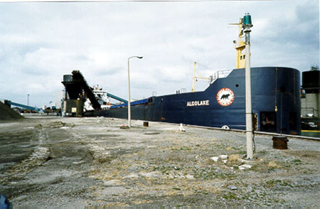
Self-unloading bulk carrier Algolake
Long Point Bay, Lake Erie, Ontario
The Transportation Safety Board of Canada (TSB) investigated this occurrence for the purpose of advancing transportation safety. It is not the function of the Board to assign fault or determine civil or criminal liability. This report is not created for use in the context of legal, disciplinary or other proceedings. See Ownership and use of content.
Summary
Before dawn, while proceeding across Long Point Bay, Lake Erie, Ontario, the Algolake experienced heavy vibration and came to a stop. The vessel had struck and grounded on shoals near the Nanticoke channel. The vessel was refloated the next day with the assistance of a lightering vessel and three tugs.
Factual information
| Name | "Algolake" |
|---|---|
| Port of registry | Sault Ste. Marie, Ontario |
| Flag | Canada |
| Official number | 318430 |
| Type | Self-unloading bulk carrier |
| Gross Tons Footnote 1 | 22 852 |
| Length | 219 m |
| Draught | Forward: 8.28 m Aft: 8.38 m |
| Built | 1977, Collingwood, Ontario |
| Propulsion | Two 10-cylinder Pielstick diesel engines rated at 6620 kilowatts; single screw, controllable pitch propeller; bow thruster |
| Crew | 29 |
| Passengers | 0 |
| Registered owner | 3013286 Canada Inc. |
History of the Voyage
On 10 October 1998, the Algolake departed Superior, Wisconsin, bound for Nanticoke, Ontario, with 32 340 short tons of coal.
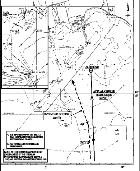
At 0534 Eastern daylight time on October 14, at Long Point Bay, Lake Erie, the Algolake altered course to 354° gyro (G) and proceeded at an average speed of 10.8 knots. It was dark, and winds were near gale from the west at 28 knots, gusting to 35 knots. The planned course on the navigation chart for the area showed a course of 355° true (T). The buoys marking the Nanticoke channel were laid over by wind, sea, and swell, which adversely affected their ability to be detected by radar.
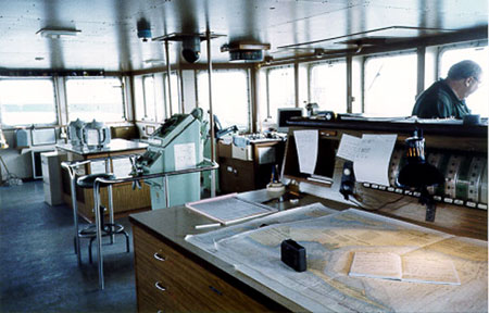
On the bridge were the first mate, a first-year navigation cadet, and a helmsman. The navigation cadet was instructed to keep a lookout and take position fixes every half hour. He stood at times at the chart table and occasionally glanced into the automatic radar plotting aid (ARPA) radar. The first mate had confidence in the cadet's ability to assist in bridge watchkeeping tasks. A night order book instruction was that the master was to be called 30 minutes before the next course-alteration point, abeam of Nanticoke shoal buoy, about half the distance across Long Point Bay. At the alter-course point, which was a shortcut to enter the Nanticoke channel, the intention was to proceed on a course of 338°T for 2.5 nautical miles (M) and enter the Nanticoke channel, keeping buoy EN10 to starboard.
At 0615 the navigation cadet marked the position of the Algolake on the chart. The off-track error at this time was 0.42 M to the east. This was not entered in the bridge logbook. The first mate checked the cadet's position fixes. No adjustment to the course to steer was made, but steering was changed from automatic to hand steering. No other position fix was made before running aground.
At 0625 the master came up to the bridge, prior to being called, and engaged in a conversation, not related to navigation, with the first mate. Part of the conversation centred around the departure time of the Canadian Transport from Nanticoke. The first mate indicated that the presence of the master increased his level of confidence.
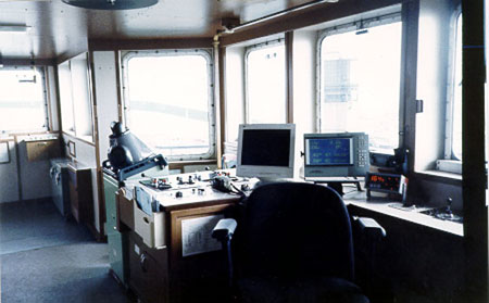
The master started up the electronic chart display (ECDIS) unit. In the start-up mode, the ambient light from the unit's display screen "daylight mode" was significant. The master later indicated that he did not get his night vision established for a few minutes because of this bright light. For five or six minutes, the master attempted to get the ECDIS unit to operate properly but was not successful. The display screen was locked onto the area of western Lake Erie showing Pointe aux Pins and Southeast Shoal and vicinity and had been in this state since the previous day. The ECDIS unit was left in the "on" position, so that the service technician could see it in the locked state, and the monitor was turned to the "off" position, which reduced ambient light.
At 0646 the master adjusted the pitch controls to bring the vessel to half speed and marked the manoeuvre in the bridge logbook. The master did not specifically inform the first mate that he was briefly assuming responsibility for navigation, and this was not mutually understood or agreed upon. At the time of the investigation, both the first mate and the master indicated that the first mate maintained control of bridge operations. No one on the bridge confirmed the vessel's position at the time of the speed reduction. Between the time that the master arrived on the bridge and the reduction in the ship's speed, the Algolake passed but did not alter course at the course-alteration point abeam of Nanticoke shoal.
At approximately 0648 the master went below to his cabin. Within one minute, he felt the vessel shudder and vibrate heavily. He quickly ran to the bridge to see that the helmsman had the wheel hard over to port and that the Algolake was slowing down. At 0650 the Algolake was hard aground in position latitude 42°45.8′ N, longitude 080°01.96′ W, and the gyrocompass showed 343°G.
The vessel had overrun the course-alteration point by 2.1 M and was 0.8 M SE from the Nanticoke channel and three cables from gas well heads. Immediately after the grounding, the master instructed the crew to take soundings. It was discovered that the vessel was holed and taking on water in the forepeak and No 5 port tank. The pumps were able to keep up with the influx of water. The holes were plugged with temporary cement boxes which were later strengthened in Port Colborne, Ontario. After transferring cargo from the No 1 cargo hold to the No 3 cargo hold, the crew tried to free the vessel with three tugs, but without success. The Canadian Transport, which previously had discharged its cargo in Nanticoke, was used to lighter the Algolakeof approximately 6000 tons. The vessel was scheduled for permanent repair work at Port Weller Drydock at the end of the shipping season.
The master held a Canadian Ocean Navigator I certificate and was determined by company medical personnel to be medically fit, as of March 1998. He had taken bridge resource management (BRM) training in Newport, Rhode Island, two years earlier. The master joined the Algolake in July and since that time had piloted the vessel 10 times, inbound and outbound, to and from Nanticoke. He was to be relieved for his holidays by another master upon arrival at Nanticoke. He had sailed as master for the previous six years. He was well rested at the time of the occurrence.
The first mate held a Canadian Inland Master certificate and was determined by company medical personnel to be medically fit, as of March 1998. He had taken BRM training two years earlier, in Newport, Rhode Island. Twenty years previously, he was employed as master for several years and as first mate since then with different shipping companies. He was well rested at the time of the occurrence.
The navigation cadet was a first-year cadet with Georgian College and, before joining the vessel in May 1998, had eight months of marine training. The training did not include the use of radar or any other piece of bridge electronic equipment. Since joining the Algolake, the cadet was instructed by the master to assist in the watchkeeping duties of each of the three officers, for approximately two-month periods, on each respective watch. He had not been familiarized with BRM concepts, either by Georgian College or by the first, second, or third mates during his first period of service on board a ship. He was well rested at the time of the occurrence.
At the time of the occurrence, the company had an ISM Document of Compliance at its shore-based operations office and a Safety Management System Certificate aboard each of its vessels, including the Algolake. The company has been pro-active to ensure that the masters and mates receive regular training which includes courses in pilotage and BRM. Refresher training is provided for personnel, whenever the company is informed that an individual's human performance is an issue.
The ARPA radar was operating and located beside the ECDIS unit at the forward starboard bridge window, and an ECDIS repeater was at the centre control console. The port radar was on stand-by. The vessel is also equipped with Loran C and a Differential Global Positioning System unit.
The vessel's paper graph depth sounder had not been operating effectively for several months when a request was made to have it serviced or replaced. Vessel and company personnel were concerned about the serviceability of the depth sounder. Service had been arranged for Nanticoke and pricing had been received for a replacement unit, if the technician could not get the unit fully functional. The service technician, however, was not aware of instructions to service the depth sounder. It is possible that there was some miscommunication between the company and the service technician's Montreal office regarding the service call details.
Analysis
No Formal or Mutually Agreed Handover of the Watch
The master had left instructions to be called 30 minutes before the next course-alteration point, abeam of Nanticoke shoal buoy. This would have been around 0610. The master arrived on the bridge at 0625, however, without having been called.
At 0646 the master moved the engine controls to half speed and wrote the entry into the bridge logbook. This action most likely gave the first mate the impression that the master was taking command because the vessel was arriving at a port. Although the master's action was not formal, it was implied; but the first mate did not question it.
The IMO International Convention on Standards of Training, Certification and Watchkeeping for Seafarers, 1978, Section A-VIII/2 part 3-1 23.3 states:
The officer in charge of a navigation watch shall: continue to be responsible for the safe navigation of the ship, despite the presence of the master on the bridge, until informed specifically that the master has assumed that responsibility and this is mutually understood.
By being acquiescent, rather than questioning who was in charge, the first mate was distracted from carrying out his responsibilities. It was not until the master went below that the first mate realized that the master had not taken command. The master took unilateral action with regard to the operation of the ship, without a position check follow-up. Apparently, he made an assumption that the first mate or cadet would do so. If the master, officer, or cadet had checked the vessel's position, it would have shown that the Algolake was standing into danger.
Bridge Resource Management
Despite company efforts, no formal BRM regime was in place on the bridge of the Algolake, because the responsibilities of those participating in the navigation of the vessel were neither defined nor clear. Apparent action or inaction by individuals involved in the navigation of the vessel resulted in others making false assumptions about their own and others' responsibilities.
When the master arrived on the bridge, conversation not related to the vessel's navigation took place. The conversation detracted from paying close attention to the navigation of the Algolake, especially during a time of darkness, bad weather, and while approaching an area of constricted navigation and navigation hazards.
Reliance on Untrained, Inexperienced Personnel
Although the first mate's last instruction to the cadet was to obtain a position fix every half hour and observe what was happening, given the circumstances, a half-hour period between fixes was inadequate. Despite the first mate having confidence in the cadet's ability to assist in watchkeeping duties, the cadet lacked experience of radar watchkeeping. His level of training and experience was such that he did not, and could not, question the first mate's instructions. If the frequency of position fixes had been increased, it would have shown that the course being steered by the Algolake was standing it into danger.
Occasional glances at the radar screen, whether or not the cadet was able to interpret what was seen on the radar, were insufficient to navigate or to monitor the vessel's progress. The first mate incorrectly assumed that the cadet would alert him to any deviation from the general course plan, laid out on the navigation chart, and of any navigating obstacles.
Preoccupation with ECDIS Equipment
Problems with the ECDIS unit had begun the previous day while downbound from Lake Huron and in the St. Clair River. The master had requested the shore superintendent to arrange for a manufacturer's service representative to look at the unit upon the vessel's arrival at Nanticoke. Until a properly qualified ECDIS technician had examined and serviced the unit, the information it provided could not be relied upon.
When the master arrived on the bridge, in addition to engaging in non-essential conversation, he also became preoccupied with the ECDIS unit, which he knew had been malfunctioning. As the vessel approached Nanticoke, its manoeuvring room diminished. The master's attempts to operate the ECDIS distracted his attention from the need to confirm the vessel's position by the other means available. The ambient light from the unit's display screen also affected the master's night vision and reduced his ability to appreciate other visual clues to the vessel's position.
Standard of Watchkeeping by Bridge Personnel
The Canadian Recommended Code of Navigation Practices and Procedures, TP1018, section 21, states "Fixes should be taken at frequent intervals; whenever circumstances allow, fixing should be carried out by more than one method".
Between 0534, rounding Long Point Bay, and 0650, the time of running aground, there was only one position fix, at 0615.
The vessel's position at the time of the speed reduction was not confirmed by either the master or the first mate. No position check was made as the vessel approached a course-alteration point. The next course-alteration point was rapidly approaching and it would take some distance for the vessel to reduce headway. Within a few minutes of movement beyond the course-alteration point near Nanticoke Shoal, the water depth was rapidly decreasing and there was not enough time to alter course in order to keep the vessel from running aground.
Although winds were strong and westerly and the vessel was proceeding at a reduced speed, no allowance was made for leeway. The vessel continued on a course of 354°G.
Confidence Level
Although the master of the Algolake came up to the bridge before being called by the first mate, his arrival may have increased the first mate's level of confidence and relaxed his watchkeeping routine. Because the vessel was very near to the point where the master would normally have taken over the con, it is most likely that the mate expected that the master would imminently take control of the navigation of the vessel but, in the event, he did not.
Depth Sounder
Vessel and company personnel did not appear to be greatly concerned about the serviceability of the depth sounder because most of the vessel's areas of operation throughout the Seaway and Great Lakes were well known.
The paper graph depth sounder, located at the back of the wheelhouse, had not been working properly for some time. While depth sounder information is normally more useful to vessels approaching ports from a large body of water, in known shallow areas of Seaway operations, its usefulness is limited. However, had there been a working depth sounder fitted with an alarm, it could have given a warning that the vessel was approaching shallow water.
Findings
- No formal BRM environment was in place on the bridge of the Algolake, and the responsibilities of those participating in the navigation of the vessel were neither defined nor clear.
- The interval between position fixes was too large to effectively monitor the vessel's progress along her intended track.
- The influence of strong westerly winds caused the Algolake to drift east of her intended track, but no allowance was made for this leeway.
- As the vessel approached a course-alteration point, the master and first mate engaged in a conversation not related to the navigation of the vessel.
- The master, attempting to operate a defective ECDIS, became distracted by a non-essential task which also affected his night vision.
- The master did not specifically inform the first mate that he was briefly assuming responsibility for navigation, and this was not mutually understood or agreed upon.
- After the 0615 vessel position plot, no further position fix was plotted until the vessel ran aground at 0650.
- The Algolake grounded in shallows, ESE of buoy EN10, having passed the course-alteration point by 2.1 M.
- Considering that the vessel's ECDIS and depth sounder were inoperative, a less-than- adequate radar watch was kept.
- The navigation cadet was unfamiliar with the principles of BRM and was not sufficiently trained in the use of radar and other navigational aids to be able to assist effectively.
Causes and Contributing Factors
The Algolake grounded when the vessel proceeded past a course-alteration point, in darkness and near-gale weather. Contributing to the occurrence were the absence of a bridge resource management environment, undefined or unclear responsibilities of those participating in the navigation of the vessel, and the non-use of all available means to monitor the vessel's progress along its intended track.
Safety Action Taken
Action taken
As a result of this occurrence, Algoma Central Marine has taken the following actions:
- both the master and the chief officer were required to attend a refresher BRM course;
- the ECDIS unit was serviced and repaired;
- a new depth sounder was installed on board the vessel;
- instructions were sent to the fleet on the proper use of cadets while on a navigational watch; and
- a third party was recruited to carry out an independent audit of bridge practices of a number of Algoma ships. These audits will continue in the future.
This report concludes the Transportation Safety Board's investigation into this occurrence. Consequently, the Board authorized the release of this report on .
Appendix C - Glossary
- ARPA
- automatic radar plotting aid
- BRM
- bridge resource management
- ECDIS
- electronic chart display and information system
- G
- gyro (degrees)
- IMO
- International Maritime Organization
- m
- metre(s)
- M
- nautical mile(s
- T
- true (degrees)
- °
- degree(s
- ′
- minute(s)


